Ali Dexter
Senior Project Manager – City Engagement
Samantha Bird
Specialist Planner
Contributions to this consultation were reported to council and the planning proposal and draft DCP amendment were approved.
Senior Project Manager – City Engagement
Specialist Planner
We are now drafting the Local Environmental Plan document. When finalised it will be available for viewing on the NSW Government website.
We have now finalised our studies on traffic, transport, social sustainability and built form in the Danks Street south precinct.
This work and feedback from the public exhibition will now be reported to the Transport, Heritage and Planning Committee on Monday 3 December 2018 and the Central Sydney Planning Committee on Thursday 6 December 2018.
We are finalising our studies on traffic, transport, social sustainability and built form in the Danks Street south precinct.
This work has been undertaken in response to community feedback from the 2017 public exhibition of the planning proposal and draft development control plan. We will soon report to Council and will update this page.
A draft voluntary planning agreement for 903–921 Bourke Street, Waterloo is now on public exhibition. This follows the exhibition of the planning proposal and draft development control plan for the Danks Street south precinct in 2017.
You can read the agreement and make a submission by 30 November 2018.
Please note, the draft agreement has no reference to the proposed building heights or built form on this site and it does not imply approval of the proposed planning controls for the wider precinct.
If development of the site proceeds, this agreement seeks to ensure the following public infrastructure is provided when the land is developed:
If the planning proposal and draft development control plan are approved by Council, we will start the detailed design of these public spaces in 2019. There will be opportunity for community input on the character and future use of these spaces through the design process.
For more information on the voluntary planning agreement, please contact Brett Calear, Senior Project Manager, Planning Assessments on 02 9265 9333 or email [email protected].
Through the Open Field Agency project, artists Hugo Moline and Heidi Axelsen of MAPA, worked with the community to gain early input on the character of future public spaces in the area.
If the planning proposal and draft development control plan are approved by Council, MAPA will work with landscape architects engaged by the City to develop the public space designs. Please contact Hugo and Heidi if you're interested in being involved.
We have been working on a range of different studies and undertaken further investigations, including traffic and transport and a social sustainability appraisal to assess local social infrastructure.
These documents are being finalised and will be made public when the exhibition outcomes are reported back to Council.
We conducted traffic surveys in November and December 2017 to better understand existing traffic conditions and how many people travel by car to work or university. These surveys recorded similar counts to our previous surveys. The report is now being finalised by our transport consultants.

We are working with Transport for NSW to improve transport in the short term, especially bus and rail capacity, reliability and travel times.
Infrastructure Australia has updated its infrastructure priority list and it includes 2 City projects, reflecting the focus on managing congestion as the population grows in Sydney.
We are pleased to see light rail for Green Square (southern Sydney to CBD public transport enhancement) is a high priority over the next 5 to 10 years. The inner Sydney regional bike network (active transport (walking and cycling) access to Sydney CBD) is also listed as a priority in the next 5 years.
Infrastructure Australia’s high priority for these projects supports our continuing advocacy to the state government to make them a reality.
We have also suggested the state government extend the proposed Metro West rail line to the south-east with a stop at Green Square. In March, the state government released an update on the Metro West project and you can provide feedback until 18 May.
In 2017, we made a detailed submission to Roads and Maritime Services on the concept design for the proposed Alexandria to Moore Park Connector. The roadway is proposed to run south of the Danks Street South precinct (from Euston Road, east to McEvoy and Lachlan streets). The original concept design would create a barrier through Green Square from the south, potentially affecting people in buses, or on bikes or foot. We are calling on the state government to undertake a full environmental impact statement on the proposal.
We are continuing to work through the built form issues. This is a complex process particularly on the former Sydney Water site where the 2 towers are proposed.
We recently met with Roads and Maritime Services and Transport for NSW to discuss issues raised in submissions. It was agreed the City will undertake traffic surveys to better understand existing traffic conditions and how many people travel by car to work or university during the week and at weekends. The surveys will be undertaken after the spring school holidays.
We also met with Sydney Water to discuss access requirements to its 2 heritage-listed buildings that provide water to the eastern suburbs from Potts Hill.
To understand the issues many people raised in submissions and to establish the current bus service capacity, we spent a morning observing how well the buses travelling north were servicing the area in the peak period. We monitored these bus stops:
We found:
While this was not a formal survey or passenger count, it is useful information to inform our future discussions with Sydney Buses. Particularly around future capacity planning of services for the short to medium term.
We are still working through the built form issues. This is a complex process particularly on the former Sydney Water site where 16 and 20 storey towers are proposed. It will likely take some time before we can report back on this.
In our last update we stated it was an 8 minute walk to Green Square station and a 15 minute walk to Redfern station. The times were measured from the centre of the Danks Street South precinct, and were walking times of the project team.
We have now amended these times to reflect the standard average walking pace of 5 minutes for 400m and identified specific points of origin and destination. The amended details are shown in the July update below.
We have reviewed all submissions and are developing further built form options in response to issues raised.
Many submissions raised the need for more public transport to meet current and future demand.
The City’s CEO has written to the Secretary of Transport for NSW requesting that the agencies work together to develop a plan that improves transport in the short to medium term. We will keep you updated on the progress of this work.
While the City is not responsible for public transport services, we can improve walking and cycling options on local streets.
From the corner of Lachlan and Bourke streets, Green Square station is a 12 minute walk. From the corner of Young and Danks streets, Redfern station is an 18 minute walk. Riding a bike from the corner of Lachlan and Bourke streets to Town Hall (corner of Druitt and George streets) takes around 18 minutes and is mostly along the separated Bourke Street cycleway.
You can request a map, free personalised route-finding advice, and book low cost cycling and bike maintenance courses at sydneycycleways.net. The City also holds regular events at Crystal Street with free bike tune ups and route-planning advice.
Encouraging 60 people to walk or ride is the equivalent of 1 full bus. Converting more trips to cycling and walking trips will help ease local congestion issues, while we continue to advocate for better public transport services.
We will continue to provide regular project updates on this page. For any specific questions, please email [email protected].
The formal exhibition period for the proposed planning controls has closed, however, the City is still waiting for submissions from some state government agencies.
We'd like to thank everyone who made a submission and all those who came to our drop-in session on 18 May 2017.
We have received a substantial amount of feedback, with over 220 submissions from the community.
The main issues that have been raised so far include:
We are still reviewing all submissions to establish what additional work is required. We will provide regular project updates on this page.
For any specific questions, please email [email protected].
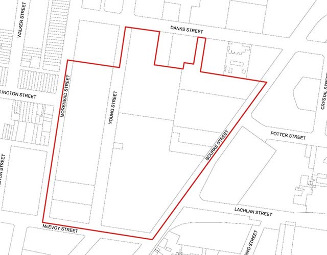
The City of Sydney invited your feedback on a proposal to amend planning controls that will guide future development of the Danks Street South precinct in Waterloo. The site is bounded by Danks, Bourke, McEvoy and Morehead streets.
The draft planning controls define where new apartments, shops, parks, roads and walking and bike riding connections would be located. New development will complement the existing vibrant community in this area. The precinct is also close to the new community facilities in the Green Square town centre.
The proposal would allow for:
The proposal seeks to amend the maximum building heights in the precinct to mainly 4 to 6 storeys. It would also allow one 20-storey tower and one 16-storey tower. This proposal doesn’t change the existing zoning or floor-space ratio (density).
You can view all the information for this proposal in the document library (below), including a document providing an overview of the draft planning controls.
When we have finished working through the site’s built form issues, the outcomes of the public exhibition and the City’s further investigations will be reported back to Council and the Central Sydney Planning Committee. If Council approves the planning proposal, it can amend the Sydney Local Environmental Plan 2012 on behalf of the Greater Sydney Commission.
